Friday, July 25, 2014

2015 IBR Goals and Objectives

"A goal without a plan is just a wish." -- Antoine de Saint Exupéry

My goal is to complete the 2015 Iron Butt Rally as a Gold Medal Finisher.  I will strive for a personal best by scoring better than my IBR 2013 16th place position.  

In my opinion, successful Iron Butt Rally riders are those who safely reach the final check point on time and with enough points to achieve their goals.  A rider applies his or her knowledge, skills, and abilities using the tools of the sport, in a balanced way among several interacting performance elements to achieve success. See "LD Riding on the Clock -- An Organizing Framework"

Goal-setting involves establishing specific, measurable, attainable, realistic and time-bounded (S.M.A.R.T.) objectives. Once these objectives have been set they become the gauge by which goal success can be measured. To achieve my goal I have identified specific objectives for each leg of the Rally.  These objectives are based on my analysis of the Ride Pace of previous IBR finishers.  This analysis reveals two significant metrics which help me identify the specific objectives to reach my goals:
  1. Point Spread:  Gold Medal finishers achieve total points above 145% of the minimum to attain Finisher status.
  2. Ride Pace:  Gold Medal finishers have an overall average around 45.0 MPH
Point Spread:  There is no way of knowing the minimum points to be considered a finisher until it is announced just prior or at the start of the leg.  This typically occurs at the opening banquet the night before the start of leg 1.  And, at the 6:00 AM  rider meetings for legs 2 & 3.  When the minimum is announced I can determine the point target (objective).

Specifically, I want to know how many bonus location points I must plan for to reach the 145% target over minimum.  Not all of the points will be bonus location points, or points I earn by successfully reaching a location and document the stop as called for by the bonus listing.  About 20% to 30% of the minimum bonus points can be derived from admin bonuses; tracking, rest, call-in and others.  By subtracting the points of the admin bonus from the 145% over minimum value I can then determine the target amount of location bonus points necessary to achieve the leg goal.  This becomes my bonus point target for the route selection task.  I will select bonus locations with the highest value for the calculated achievable miles and the available time.

Ride Pace:   Normally, I can maintain a 45-48 MPH overall average (Ovg) while riding on the clock.  My moving average (Mvg) varies depending on the geographical area but are generally 65-70 MPH in the western US and 60-65 MPH in the eastern US.  Apply these metrics with the announced leg hours and the rest is basic math.  Reference:  Rally Leg Plan Tool -- Profile

Listed below are the planning standards/assumptions  I use to calculate the number of possible bonus locations and bonus location total time for each leg.  Combine the number of bonus locations with the target points for the leg can lead to selecting a route that meets objectives:  145% of leg minimum at a sustainable Ovg around 46 MPH

  • Planning on the Clock:  Zero for Leg 1, 2:00 hours for Legs 2 & 3
  • Fuel Endurance Distance (FED) -- 350 miles of usable fuel range with small reserve
  • Average time per Pit Stop -- 0:10 minutes each
  • Rest hours per 24 hour period -- 8 Hours to earn full value of the Rest Bonus with 6 hours for each remaining 24hr period.
  • Average time per Bonus Stop -- 0:10 minutes each or multiples of 10 min for bonus stops that require a specific amount of time greater than 10 minutes.

2015 Iron Butt Rally Leg Start/End Date/Time -- Starting and Ending in Albuquerque (ABQ) NM

Leg 1:  10:00 MDT 29 Jun, ABQ NM 82 hours to end 20:00 MDT 2 Jul, ABQ NM
  • Route Selection:  0:00 planning on the clock
  • Planning Miles:  3,772 miles = 82:00 Lhrs X 46 MPH Ovg 
  • Moving Time:  55:28 = 3,772 miles / 68 MPH Mvg
  • Pit Stop Number:  10 = 3,772 / 350 FED (rounded up)
  • Pit Stop Time: 1:40 = 10 Pit stops X 0:10 per stop
  • Rest Stop Number:  3 = 82:00 / 24 hours
  • Rest Stop Time:  18:00 = 6:00 standard (day 1), 8:00 Rest Bonus (day2), 4:00 day3
  • Bonus Stop Time:  6:51 = 82:00 Lhrs - 55:28 Mvt - 1:40 PSt - 18:00 RSt
  • Bonus Stop Number:  41 = 6:51 / 0:10 per standard bonus stop
  • Slack Time:  To be calculated after route/bonus number is determined

Leg 2:  06:00 MDT 3 Jul, ABQ NM 60 hours to end in 20:00 EDT 5 Jul, Kingsport TN (EDT)
  • Route Selection:  2:00 planning on the clock
  • Planning Miles: 2,760  (at 46 Ovg)
  • Moving Time: 40:35 (at 68 Mvg)
  • Pit Stop Number:  7
  • Pit Stop Time:  1:10
  • Rest Stop Number:  2
  • Rest Stop Time:  12:00 (4:00 day 1, 8:00 RB 2 day, maybe)
  • Bonus Stop Time: 4:14
  • Bonus Locations:  25 (at 0:10 standard each)
  • Slack Time:  To be calculated after route/bonus number is determined

Leg 3:  06:00 AM 6 July, East US 100 hours to end 08:00 MDT 10 July, ABQ NM
  • Route Selection:  2:00 planning on the clock
  • Planning Miles:  4,500 (at 45.0 Ovg)
  • Moving Time:  69:13 (at 65.0 Mvg)
  • Pit Stop Number:12
  • Pit Stop Time:  2:00
  • Rest Stop Number:  4
  • Rest Stop Time:  22:00 (split among 4 days maxing the RB)
  • Bonus Stop Time:  4:46
  • Bonus Locations:  29 (at 0:10 standard each)
  • Slack Time:  To be calculated after route/bonus number is determined

After the route is selected I will use the computed route miles, computed Mvg, pit stops, planned rest time and number of selected bonus locations to determine the slack time to the checkpoint. 
I fully expect the plan and objectives to be challenged by the operational environment as I ride the leg.  But, these organizing measurements will help me to make better decisions about changes to the plan.  Understanding how the allocation of total leg hours among the various uses aides me in maintaining a consistent ride pace and manage resources.  Once the slack time is determined I will spend it dearly.  I will seek efficiencies doing bonus. pit and rest stops.   I am committed not to purchase bonus stop time with the currency of excessive moving average MPH (speed).  Also, I am determined to get the quality rest I need during each leg, as it will pay dividends when making decisions as problems and/or stress occurs. 

During training rides and rally practice I will seek to validate the performance objectives I have set for the IBR.  Chief among them are the overall average and moving average MPH.  By training to and being able to maintain these ride pace objectives I achieve the best guard against falling behind plan.  I expect to ride in extreme heat during all the IBR legs.  I will practice riding in the heat, adjusting my riding gear and establishing a hydration regimen that sustains the ride pace. Ultimately, maintaining a balance among the performance elements while riding on the clock will guide the training and preparation activities. 

Tuesday, July 15, 2014

Earth to Moon BunBurner Gold

"The Eagle Has Landed"
July 16, 2014 is the 45th anniversary of the launching of the Apollo 11 mission to land on the Moon.  In the spirit of "Every ride an adventure!" and to honor that date in history, I will ride from Earth, TX to Moon, PA, a distance of over 1,500 miles, in less than 24 hours.  (Hat tip to Rich Rulau for the idea.) 

Pre-launch staging will be conducted in Muleshoe, TX the day prior to scheduled July 16th departure from Earth.  The route after launch from Earth will pass through Amarillo, TX.  Then through Springfield IL, continuing on to the final destination of Moon, PA.  A distance of 1,511 miles according to the rocket scientists at Bing Cartography.  By doing a IBA Challenge Ride from Earth, TX to Moon, PA one earns "IBAnaut" bragging rights. (see disclaimer below)

BubblerGPS Pro map via SpotWalla Tracking Central.  This map link will show my ride up to Muleshoe, Earth to Moon, and the ride back home.  The map below shows my Spot Gen3 map of the Earth to Moon ride only.


Launch Pad
Wednesday, 7/16:  Launch pad was at the Alon station in Earth.  I had previously verified the accuracy of the all important IBA starting dated business receipt, of DBR.  I arrive at 0230 for a cup of coffee to go with my breakfast bar.  Got a backup DBR in the store just in case.  The morning air was very comfortable, in the low 60s.  I put on my electric gear before departing the Muleshoe hotel.

Segment 1 - Earth to PS1:  I launched out of Earth right on schedule at 0300.  DBR was 0257 and I pressed the starting SPOT button right at 0300.  Pit stop 1 was just west of Oklahoma City.  I would ride north through Amarillo then I-40 east.  I had my FLIR system activated to help me detect warm blooded critters along the path of travel.  Good thing too for just prior to Amarillo there was a deer on the I-27.  I was alerted to it well outside the range of my head lights or about 1/4 mile.  By the time it was in light range it had noticed me and was moving erratically.  I scrubbed off speed and waited for it to decide where to go.  The rest of the ride was good with just a couple of rain sprinkles along the way.  Arrived at Pit Stop 1 a few minutes early at 0725, but who's counting?

Segment 2 - PS1 to PS2:  Departing the Oklahoma City area I took a northeasterly route to the towards Tulsa and beyond to Springfield MO and PS2.  By this time the weather had cleared but the temperatures were still on the chilly side.  A cold front had moved through the area the night before and pushed all the hot air to the south.  Segment 2 was uneventful, just good riding.  There were some tolls along this route and I was delayed some at the three pay points.  But, traffic was good and no issues.

Segment 3 - PS2 to PS3:   Ride pace has been good with no traffic delays.  Hit the Springfield MO metro area and arrived at the preplanned station about 10 minutes early.  My goal for having planned stops was not to be a slave to the schedule but to provide me information about the ride pace.  Weather still pleasant with temperatures in the mid 60's.  During planning I picked stations with easy off easy on  locations and did google earth recons for each station.

Segment 4 - PS3 to PS4:  By the time I arrived at PS4 I had been on the move 18 hours having stopped three times for pit stops.  Still, I felt good and no issues with comfort stress.  I arrived at pit stop 4 with a few minutes to linger while off the bike.  I took this opportunity to get shed of the accumulated TexMex and other meals that had been processed.  It is amazing how much better riding is after a healthy purge, LOL.

Segment 5 - PS4 to Moon:  The accumulated miles were starting to wear on me.  My knees in particular were creating comfort stress.  Standing up a few times takes care of this as well as extending my legs out on my highway pegs.  Still, 20 hours in the saddle is a long time.  So, I pulled off at a nice Love's travel center, had a cup of coffee and stretched my legs a bit.  It felt good and the coffee perked me right up for the final trek into Moon.  I turned north near Wheeling WV and did the river road.  Was a great ride even in the dark.  I had my FLIR system on since dusk and it was working wonderfully.  Didn't seen any critters but was amazed at how the large cooling towers and smoke stacks appear in thermal imagery.  I looked like something out of a science fiction movie.

Lunar Landscape
The "HardTxRider" has landed:  Arrive at Moon right at 0130.  Got the clock stopping DBR at the Sheetz station, went in to by some food and rode across the street to the Super8.  Saw Rich's bike parked right out front so I pulled in right beside him.  Got the clerk and her assistant to witness my IBA BBG form.  Another Iron Butt ride in the baggie.  I got up the next morning around 0800 and had breakfast with Rich in the lobby.  Then I headed to the township to find a couple of photo ops.  What an adventure!


Ride Statistics:  GSA Odo 72,572 to 74,089 = 1,516 Miles, GPS 1,517.4 Miles
  • Total Time:  22:33 DBR to DBR
  • Moving Time:  21:30
  • Stopped Time:  1:03
  • Moving Avg MPH:  1,517.4 / 21:30 = 70.6 MPH
  • Overall Avg MPH:  1,517.4 / 22:33 = 67.4 MPH


ATGATT
"IBAnauts"
Tuesday, 7/15:  Pre-launch staging took place in Muleshoe, TX.  About 20 miles west of the Earth launch pad.   I met up with fellow IBAnauts Rich Rulau and Perry Linn.  Rich was doing a BBG with a 2AM scheduled launch.  Perry's intention was a SaddleSore 3,000 Earth to Moon to Earth.  Rich, Perry and I went to a local TexMex eatery for the traditional IBAnaut dinner.  We got our IBA witness forms documented, with the help of "BikerBill" Bill Norris who rode in from Lubbuck. I entered pre-launch sleep period at 2000 with a 0200 wakeup.


Earth to Moon planning with proposed route and mission profile.  The mission profile contains the time, speed and distance calculations as well as the planned enroute fuel stops.  The mission profile contains the Garmin BaseCamp generated route and anticipated travel times for each route segment beginning at the Earth launch location through to the Moon landing location.  This raw data is then fed into the Rally Leg Plan Tool to time out the entire mission giving estimated times of arrival at all route segments and to the final landing location in Moon.  It can be used to compare planned and actual riding times.


I am planning to complete an IBA BunBurner Gold challenge ride during this event.  It requires me to ride, and document to IBA standards, over 1,500 miles in less than 24 hours.  By choosing to ride a BBG on a specific date, from and to specific locations, means I don't get to pick the weather or avoiding congested areas.  About the only flexibility I get is the departure time and expected waypoint times along the route.  So, this type of BBG is more challenging that the optimally chosen route and day to ride.  If for some reason I don't finish the ride in less than 24 hours I will apply for a regular BunBurner 1,500 which can be accomplished in less than 36 hours.  Either way it's going to be a nice motorcycling adventure.


The return flight from Moon is still in the planning stages.  Of course, I hope to make it an adventure out of that ride.  So, I'll be scouring the space between Moon and my home base for fun opportunities.  Stay tuned.....

OK, here's a fun idea.  Do any IBA SaddleSore or BunBurnner ride between Earth, TX and Moon, PA and lay claim to a "IBAnaut" designation.  Ideally, starting on an anniversary date of any Apollo Mission.  All rides should start from Earth, TX of course, unless you are an eastern extraterrestrial.  Just think of the fun combinations:

  • BunBurner 1,500 -- One way from Earth to Moon in less than 36 hours
  • SaddleSore 3,000 -- Round trip from Earth to Moon back to Earth in less than 72 hours
  • BunBurner Gold --  1,500 Miles one way from Earth to Moon in less than 24 hours
  • BB Gold 3,000 --  Round trip from Earth to Moon back to Earth in less than 48 hours
  • Other interesting combinations....

NASA Apollo Missions

Apollo 11 -- 16 July 69 Launch date
Apollo 12 -- 14 November 69 Launch date
Apollo 13 -- 11 April 70 Launch date, DNF
Apollo 14 -- 31 January 71 Launch date
Apollo 15 -- 26 July 71 Launch date
Apollo 16 -- 16 April 72 Launch date
Apollo 17 -- 7 December 72 Launch date
No other manned Earth to Moon missions

Disclaimer:  The designation "IBAnaut" is not an official Iron Butt Association label for any ride.  Just my attempt to add a little fun to the event.

Friday, June 20, 2014

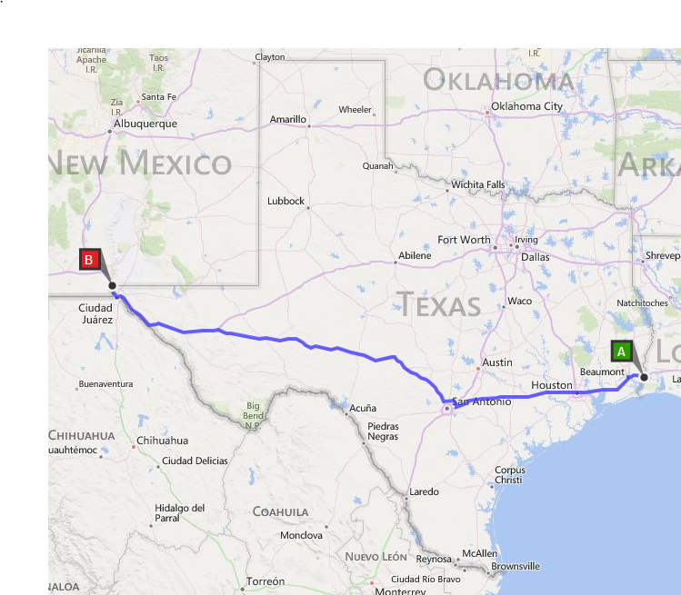
Texas I-10 Solstice 'Day Ride'

Time for another Hard Riding Adventure!  On Friday I'm heading to Orange, TX for the start of the TX I-10 Solstice Day Ride.  I'm hoping to see other riders at the Texas Information Center at Exit 880, I-10 around 6AM on Saturday.  It's going to be fun.

See:  Full SpotWalla Map
 
Sat 2028:  Arrived at the finish in Van Horn.  I rode 1,014.7 miles between sunrise in Orange and before the 2109 sunset in Van Horn.  Was a fun ride and I highly recommend it.  My plan is ride the exact route and times for the rest of the Four Seasons rides in Sep, Dec and Mar.  It will be interesting to see how the time of year, weather and traffic affects the results.  I think I'll do up a spreadsheet to track the significant items for each ride.  Stay tuned.....

Sat 1820:  The temps got into the triple digits on this segment.  By the time I reach the outskirts of El Paso it was 103F with a hot cross wind.  I got Anthony long before official sunset.  It was 1720 MDT in Anthony.  Met Lowell Vahl, MTF member,  who was on his own ride.  We chatted while I was doing my pit stop routine while on the clock.  I drained my bladder, filled the tank and tasty good bottle, did the paperwork and headed out.  Traffic through El Paso was slow but not congested.  The speed limit is 60 MPH.  As usual I stayed with the flow of traffic. 

Sat 1440: Second pit stop was at Fort Stockton.  It was brief as was the last one near San Antonio.  The temperatures were mid 90s and somewhat dryer.  Still overcast with occasional showers.  They were refreshing.  I calculated the 'Sip Rate" of my 100 oz CamelBak hydration system so at 95f I take 5 sips ever 15 minutes.  This ensures I keep enough fluids flowing through me for the riding conditions.  I did not have to stop one time to pee between planned refuel pit stops.  It used to be hit or miss with my drinking.  Either I drank too much too fast and had to stop or drank too little.  So, this calibration seems to work better.  I used the table in the hot weather riding article below to develop the sip rate for each 5F starting at 85F.  Anal, I know.....

Sat 1050: Made the first pit stop just northwest of San Antonio after leaving Loop 1604.  The ride through Houston was smooth given it's Saturday.  Temperatures were pleasant but still rather humid.  Started to pick up some showers near Comfort.  Rather overcast with little detectible wind.  Hit the 80 MPH mark just crossing the Kerr County line at MM 492.  By the time I reached Ozona the showers had come back.  No steady rain, just 1 mile showers.  All my riding gear, with the exception of Klim summer weight gloves, are Gore-Tex so the rain shower are not a reason to stop to put on "wet weather" gear. 

Sat 0530:  Heading out early to make sure I will start the Four Seasons SaddleSore 1,000 by 0551, the official time of the summer solstice.  I want to get the starting clock DBR at the Exxon around 0545, have a cup of coffee then ride to the Texas Information Center for the sunrise start at 0614.  Got no idea how many motorcyclist will be there other than the few I know about who have contacted me.  But, I'll take a couple of pictures and post them later after I've finished the ride. 

I will start out with a full tank and refuel twice before reaching Anthony.  Then the final segment back to Van Horn to finish the SS1000.  Chat with you later.

Fri 1700:  Arrived in Orange.  It was a warm ride with temps in the low to mid 90s.  Except through the showers then it cooled off to mid 80s with lots of humidity.  I checked out the Exxon station near the Days Inn, where I'm staying, to verify the date, time, city and state information on the fuel receipt.  All is in order. Had several text messages from others doing to ride tomorrow.  Most are turning in early.  I had dinner at Senior Taco, cheap Mexican, but tasty.  Got my witness form signed off in the parking lot of the motel.  I'm set.  Going to reset the SpotWalla map to start recording tomorrow morning.

I'm going to extend the adventure by doing the summer solstice requirement for the IBA Four Seasons challenge ride.  Doing a SS1000 on each of the solstice and equinox events :  Jun 21 5:51 AM CDT, Sep 22 9:29 PM CDT, Dec 21 5:03 PM CST, Mar 20 5:45 PM CDT  Source:  Time and Date  I will be using the same route for each of the Four Seasons SS1000 rides.

I'm evaluating my hot weather reading gear and hydration strategy on this ride.  I have calculated the number ounces each mouth full sip from my CamelBak hydration system and used that measurement to establish a sip rate per 1/4 hour requirement for each 5 degrees above 80F.  A bit anal, but adequate hydration while riding long distance is essential when on the clock.  See Tom Austin's article in Iron Butt Magazine linked below for some prospective.

The Event  Ride Across Texas - Border to Border, Sunup to Sundown
A - Orange to B - Anthony

Ride Interstate 10 from Exit 880 east of Orange, TX, starting at official sunrise and ride to Exit 0 at Anthony, TX arriving before official sunset.  877 Miles, border to border, east to west.  Saturday, June 21, 2014, is the summer solstice and longest daylight period of the year.  Official sunrise at Orange TX is at 6:14 AM CDT with official sunset in Anthony TX is at 8:16 PM MDT.  That affords a rider 15:02 to cover the 877 miles. 

This is a "Rendezvous Ride" type event designed to extend ones motorcycle riding horizons,.  Meet up with others before and at the start.  Then head out by yourself or with a riding partner.   The routing is easy with fuel stations, cell phone coverage and efficient highway speeds all the way.  Meet up with friends at the finish as desired.  It will be "HOT" so, check out these tips for Long Distance Riding In Hot Weather, courtesy of Iron Butt Magazine.

Schedule
Friday June, 20:  Rendezvous in Orange TX, dinner and camaraderie. 
Saturday June, 21:
  •  6:14 AM CST -- Depart from the Texas Information Center,  I-10, Exit 880
  •  8:16 PM MDT -- Arrive at the Pilot Travel Center in Anthony TX, I-10 Exit 0
Sunday Jun 22:  Head back home.

Iron Butt Association -- SaddleSore 1,000 certification option.  Continue on from Anthony back to Van Horn and document arrival within 24 hours of starting DBR.   To certify this ride for the IBA will require documentation:  Start/Finish witness and documented fuel log with supporting dated business receipts.  See IBA SaddleSore 1,000 Rules.


Ride Planning
  • Miles:  877 Miles, West on I-10,  Exit 880 to Exit 0, via 1604 Anderson Loop if desired
  • Total Time to Allocate:  15:02 Orange sunrise 06:14 CDT to Anthony sunset 20:16 MDT
  • Moving Time:  12:33  Source:  Bing Maps
  • Pit Stops:  2:39 Refuel, Refresh, Repair as necessary
IBA Archive of Wisdom -- 29 Tips for Long Distance Riding. DYI LD Riding Training

Wednesday, June 11, 2014

The BunBurner Gold Trifecta + Insanity

Ride 1,500+ miles in less than 24 hours multiple days in a row. 

WARNING:  This Xtreme! motorcycle event is being performed by an experienced, but still amateur, long distance motorcyclist, on the public highways, actively observed by LEO of multiple jurisdictions, in whatever weather and traffic that happens along the route, without permission, endorsement, authorization, encouragement, or even a note from his Mother! 

Greg Rice is one of my IBA comrades.  He has asked me to be his turn around witness while he rides the BunBurner Gold Trifecta, the weekend of June 14.  This Iron Butt Association certified challenge ride consists of three consecutive BBG's.  Each of the three BBG must exceed 1,500 miles and be ridden in less than 24 hours.  He may do a 4th BBG if he's feeling good.  This blog posting is a peak inside the extensive planning, preparations and conditioning required, to maintain the consistent ride pace, manage resources, rest and risks, to be successful.  You can follow along with Greg via the SpotWalla map below.

SpotWalla Map -- Click this link to see Greg's full map.
Where's Tim

(During Greg's BBG Trifecta attempt I will be posting updates, pictures, and ride following observations below, with the latest posting at the top.)  Current Weather Maps

Congratulations!  He did it....and with the style and flare we've come to expect from Travel_Man. 


Tue 2310:  Success!  Greg arrived at the Ely finish with  time to spare. 
Tue 1915:   As Greg approaches the AZ/NV border he is entering the final stretch to the Ely finish.  It's about 270 miles and around 3:30 to the conclusion of the BBG Quattro.  Still has to negotiate rush hour traffic through Las Vegas, but I wouldn't expect that to be too tough of a challenge give what Greg has accomplished so far.   
Tue 1200: It is just 1000 as Greg approaches Albuquerque and hopefully rush hour traffic is winding down.  Greg slept in an extra hour before heading out on his 4th BBG.  He wanted to maximize his rest after the Trifecta.  His start DBR at Junction was around 0215 CDT.  Ely, NV is PDT. So, he needs to arrive at the finish by around 2300 PDT to be within the 96 hours from the 0200 EDT start on Saturday .  At his demonstrated pace that would afford him a couple hours of slack time,
Tue 0307:  Behold, The BunBurner Gold Quattro!  By now you may have deduced this epic IBA challenge ride was going to turn out to be something more than just another BBG Trifecta.  In the works and planning for some time, Greg got the blessing from Mike K to attempt, and if successful, submit for certification the Quattro.  That was back in March while he and I attended the IBA Annual Dinner.  Greg invited me to help when I suggested the name for this 'proof of concept' ride.  So, if Greg makes it to Ely, NV before 0315 EDT Wed he will have moved the BBG class bar up a notch.  But, hold the applause.  It is still subject to Mike's approval before the Quattro gets put on the IBA challenge ride menu. 

Mon 2130:  Trifecta Perfecta!  Number three is in the baggie filled with DBRs.  Oh yeah, and the witness forms.  But wait!  What now?  I guess the same old same old... refuel, refresh, replenish then REST.  Four, tomorrow is another day!
Mon 1915:  West Texas is famous for its dramatic weather.  As it would happen a gully washer of some note hit Fort Stockton just as Greg was approaching.  He could see it on his on board weather radar, and he even hung out at Balmorhea for a bit.  By the time he got to Ft Stockton the water accumulation had flooded most of the low part of town.  A semi was blown over during the storm which closed the Interstate causing Greg to go around the mess, and right into the flooded areas.  He's working through the navigation issues and is trying to get back on track.  
Mon 1500:  As Greg nears Deming NM he's about two thirds the way back to Junction.  By the time he finishes BBG3 he will been riding his Goldwing 60 hours since leaving his Florida start point.  Like many long distance riders Greg has made his motorcycle a 'comfort' zone.  What that really means is Greg has worked to eliminate all the issues that cause 'comfort' stress.  Those annoying things that if not corrected will cause a distraction from the riding task.  Check out Greg's comfort farkles using 'The Machine' link below.
Mon 0215:  On the road again.  Same route, same plan.  This is the final leg of the BBG Trifecta, but not the end of Greg's ride.   

Sun 2130:  Two down and two, uh, I mean, one more for the BBG Trifecta.  Same routine as BBG one. Refuel, refresh, replenish and rest.
Sun 2000:  I arrived back at Junction after riding to Van Horn and back.  It was warm starting around 1300, and got up to 105f as the day wore on.  Greg was riding in some of the same temps.  I was trying out my new LDComfort skull cap.  Dry, not much of a comfort difference.  Wet, only slightly more comfortable.  I'll try it again in my Texas I-10 Solstice 'Day Ride' next Saturday and let you know if I will integrate the skull cap into my 'comfort' system.  I'm sitting at the gas station waiting on Greg to show up.  Last I checked he was near Ozona.
Sun 0900:  Happy Father's Day!  Greg is almost to Lordsburg NM with the morning sun to his back.  By the time he reaches the Tucson turnaround it will be mid day.  I'm going to do riding in the local area most of the day.
Sun 0202:  Start of BBG number 2.  Junction to Tucson to Junction.  Nine hundred miles of 80 mph and the rest of the 1,520 at 75 mph.  There will be less traffic on this leg than on the leg from Florida through to Junction.  It's going to warmer though.  Once he passes Ozona Greg will be riding in desert all the way to Tucson. 

Sat 2140:  Arrived Junction way ahead of schedule.  Must have had a tailwind most of the way.  Of course, Greg does manage his pace well.  Not for a quick refuel, shower and a Quarter Pounder with cheese and some fries from McD's.  This was the easy BBG.  Riding over 1,525 miles would be tough on most any rider.  But for the BBG Master it was a good days ride.   Arriving early means more sleep.
Sat 1330:  Making good time.  Must be the smooth traffic flow on I-10.  At this rate Greg will probably make Junction by around 2215 or so this evening.  I'm heading out towards Junction, leaving around 1600, going to take a scenic route.  Greg has already made motel reservations for the both of us.  I'll pick up the keys so he won't have to mess with check-in when he arrives.  My plan is to meet him at the gas pump when he arrives and do my witness duties as he refuels.  
Sat 0900:  Greg is off to a good start a couple minutes before 0200.  He made the JAX DBR corner about 20 minutes ahead of predicted time.  The weather ahead on I-10 is looking pretty good and he should make the Alabama border around 1130 EDT...or 1046.

Ride Itinerary:  The table below is a schedule for each leg of the event.  Each BBG is considered a leg.  Each leg is divided into segments based on time, speed and distance to key route points, like route corners and the turn-around locations.  These are my calculations based on the route Greg chose.  I applied his parameters for average pit stop time, planned rest periods and his anticipated riding time for each of the route segments.  See: BBG-Q Rally Leg Plan Tool (MS Excel)

Note:  Times are listed in EDT.  Same time zone as will be posted by Greg's Spot messages and tracks.  (DBR = Dated Business Receipt)

Planning:  Being successful at this kind of long distance ride takes meticulous planning.  Selecting a route, timing out arrival times to each key way point, gas stops, rest points and witness points involves using mapping software and customized applications.  He uses his own proprietary scheduling application to provide information about his ride pace, pit stops (refuel, refresh, repair) and rest stops.  Like many in the LD community Greg uses on board navigation, weather radar, real-time traffic,  and communications equipment.  Each leg of the entire route has been plotted, documented and uploaded to multiple GPS units.  Back up documentation and even paper maps are included.

Route  --  The basic route Greg selected is starting near his home in south Florida, to Junction, TX, to Tucson, AZ back to Junction, then on to Ely, NV for the start of the "Poison" Rally  Over 90% of the route are on Interstate highways with the remainder on major US roads.  State Road Conditions:  FL, AL, MS, LA, TX, NM, AZ, NV

Ride Pace -- The key to successful long distance riding is a steady pace.  Greg will strive to maintain a consistent ride pace based on the legal speed limits, as adjusted for the flow of traffic and road conditions.  The ride pace takes into account time used for riding, pit stops and rest stops.  Good intel about current weather, ongoing construction, traffic and other issues will affect pace and navigation.   Greg has committed to a mandatory 4 hours of quality sleep each 24 hours, in a motel, at Junction, TX  (See -- Fatigue and Motorcycle Touring) 

Preparations: Like many in the LD community Greg keeps his motorcycle and gear it rally trim.   Greg whet through a major upgrade of his gear and equipment prior to the 2013 Iron Butt Rally.  Your can see the preparations Greg made to his Honda Goldwing, "The Machine"!  Things Greg did specifically to prepare for this BBG Trifecta + are listed below.

  • New Olympia AST 2 Hi-Viz jacket
  • New boots
  • New deerskin gloves
  • New LDComfort tights and top
  • Cleaned Aerostich AD1 riding pants
  • New tankbag setup, may mount a Microsoft Surface with GPS antenna
  • Changed air filter
  • Changed sparkplugs
  • New helmet faceshield and sun visor
  • Integrated the audio from the Garmin 2797 into the Gold Wing’s intercom system so I can hear the audio along with other GPS’s and radar detector and cell phone
  • Updated the maps on the GPS’s
  • Cleaned the Aerostich Hi-Viz tank panniers
  • New tires
  • Changed oil and filter
  • Changed rear gear lube

About the Rider:  Greg is regarded in the long distance community as a specialist of the BunBurner Gold, IBA challenge ride.  He already has 2 BBG Trifectas to his credit.  His riding adventures are number 1 on the Top Ten All Time SpotWalla Trips.   Listed below are Greg's IBA certified BBG challenge rides:
  • 2 Time finisher of the Iron Butt Rally with a top 10 Gold Podium finish in 2013
  • 2 BunBurner Gold Trifecta
  • 1 BunBurner 3,000
  • 13 BunBurner Gold 
Greg is committed to safe long distance riding.  He rides within his limits, the limits of his motorcycle and the limits of the riding environment.  He knows the risks of exceeding those limits and is committed actively managing the risks.   He is a well conditioned and an experienced long distance motorcycling athlete who appreciates training at the edges of his performance limits. 
So, if you want to learn more about long distance riding?  --  See the Iron Butt Association "Archive of Wisdom"


Friday, May 16, 2014

II. Over The Great Deserts To The Rocky Mountains -- GAW

Transcription Note:  Paragraph breaks are at the point of the original Road Rider transcript as are punctuation and spelling of words.
 
Waking in Reno, Nevada, on a May day morning, the 21st of the Month, I found snow falling thickly and the ground unfit for riding. Considering that I was only about 250 miles on my journey from San Francisco, I heaved a sigh that was almost a moan as I realized that I was to meet delay so soon. I had slept in a hotel - a good one as hotels go in this country - and, after a very satisfactory breakfast, I looked about for something to beguile the time away. I was in hard luck because I do not gamble, drink, smoke, or chew. The old time picturesqueness of Reno has departed, but it is still a town of the West, western, and a man of no habits is at a discount in it. There is plenty of opportunity for drinking and gambling about, but for little else. I killed some time profitably by overhauling my machine, and after dinner I concluded to get under way.

It was a quarter past two in the afternoon when I left Reno and I had lost a good eight hours of riding time. The snow had ceased falling, but the skies were still overcast and the ground very wet as I set forth toward Wadsworth and the great Nevada desert. For about 18 miles the road was fair, and then it began to get sandy. Sand in Nevada means stuff in which you sink up to your ankles every time you attempt to take a step. To further enliven matters it began to rain. Every now and then I had to dismount and walk for a stretch of a quarter of a mile. Several times the soft sand threw me because I did not respect it enough to dismount in time. A bicycle with a six horsepower motor could not get through such sand. The wheel just swings out from under, and the faster you try to go the worse it is. Walking and riding. I managed, however, to make the 36 miles from Reno to Wadsworth in four hours and there I pitched camp for the night.

It is well to put in a word of warning and explanation right here: When mention is made of the places at which I stopped and through which I passed it must not be imagined that they are all cities, or towns, or villages, or hamlets, or anything in the nature of civilized settlements. The majority of them are nothing of the sort. They are just places - and it seems a waste of good English to call them that. It is to be remembered that I started out determined to follow the line of the Southern Pacific and Union Pacific railroads as far east as Omaha, because it is the direct route. The road runs almost in a straight line across the great alkali desert between the mountain summits. To have gone around the desert, through the mountains to the north would have meant traveling many hundreds of miles more, and I would of a certainty have been lost many times, for there are nothing but trails to follow and often not any visible trail.

If you take a map of the Union Pacific Railroad you will see the line of it studded with names as closely as they can be printed. and if you have not crossed the continent you will very naturally be deluded into thinking of them as villages at least. These are the "places" through which I passed, or, rather past which I rode, for I was riding right on the tracks most of the way. They are localities arbitrarily created by the railroad. Many of them are nothing more than names given by the railroad officials to designate a sidetracking junction, and when you reach it all you see is the sidetrack and a signpost put there by the railroad; other places bearing names are mere telegraph stations, one eating stations for passenger trains, while still others are what are known as stations. These places all exist because of the railroad. It is to be remembered that it is a single track road all the way from Omaha to San Francisco, and therefore there is need of sidetracking at frequent intervals. This means telegraph houses or sheds for the operators, and in order to issue instructions definitely all places must be named. There are the section hands and their foremen - they make a place for themselves and it gets a name and a position on the map, even though there is only the house of the foreman and a couple of others for the laborers, as is often the case.

The divisions are places where the freight and passenger trains change engines. Quite often they are something of places, with from 200 to 5,000 population. There, two or three hotels will be found, several saloons, and a couple of stores. The stranger marvels to find a community even of this size in such a God-forsaken country. He wonders why anyone lives there, but if he is wise he does not ask any such question, for even though the wildest days have passed, it is a hot-blooded country still, where fingers are heavy and guns have hair triggers. At the division settlements in the heart of these wildernesses there is a great deal of home pride, and the traveler can get along best by praising the place he is in and "knocking" the nearest neighboring settlement. These settlements are supported partly by the money that is circulated by the railroad employees, the passengers who stop for meals and the ranchmen who come into the valley of the desert "to town" to get mail, ship goods and have a good time. These division towns are the rendezvous of the polyglot laborers on the railroad sections and the sportive cowboy alike, and as these elements don't mix any more than oil and water, there are some "hot times in the old town" occasionally. The reason why there is no more trouble than there is "shooting up the town" is that wily sheriffs "round up" the ranchmen when they strike town. Then it's a case of "Now, boys, let me have your guns we don't want any trouble, and I'll take care of your shooters. Be reasonable ." The boys are reasonable and as the sheriff treats all alike, they hand over their shooting irons and they are tagged by the sheriff with the owner's name and kept by him till the spree is over.  Occasionally, though, the men get to drinking and the fun begins before the sheriff is aware there is a party in town.

Wadsworth is one of these division settlements and I took a snapshot of it that gives a fair idea of the place. Like many railroad towns of the sort, it will soon become only a memory, for the Southern Pacific shops there now are to be removed to Reno and this will practically wipe out the town, which now has a population of perhaps 3,000. It is ever thus with the settlements in this region - here today and gone tomorrow. New places spring up in a week, and by the time some traveler has seen them and described them some shift of railroad interests has caused them be deserted villages and the next traveler cannot at all rely on finding things as described by his predecessor.

At Wadsworth I found lodgings at a hotel patronized by railroad men, and got some luscious strawberries for supper. I left Wadsworth at 7 o'clock on the morning of May 22 and, leaving it, said farewell to the Truckee River, and what few vestiges of trees and grass there were in this part of Nevada. Out of Wadsworth I was facing the great desert, the plains of alkali that sifts down from the mountains on each side, and which are barren of everything except sagebrush. As I stand before mounting and gaze across that parched, dull-gray waste of sand, alkali and rocks, with the spots of gray-green sagebrush, and think of parting from the Truckee River, which seemed so trivial a water course before, a pang of regret shoots through me. I know I shall miss the gurgling stream, and there is a sinking of the spirits that cannot be overcome as I face the leaden-hued skies and sands so unutterably dreary. Almost one can, in fancy, see the sign of "leave hope behind all who venture here." This is the Forty Mile Desert of Nevada that was so dreaded by the immigrants in the days when the prairie schooner, the bronco, and the mule were the only conveyances used by man to cross it. Many perished in this desert from want, and many more from the attacks of the then hostile Indians. The old overland trail is what I was following. It is what the railroad follows, and in many places the rails have been laid directly over the old wagon tracks. At times the old trail runs right alongside of the rails, and now and then it swings off for a few hundred yards, a quarter or a half mile maybe, only to wind back again to where the surveyors kept to a straight line for the railroad and removed the rocks and sand dunes that the prairie schooners digressed to avoid.


I walked the first mile out of Wadsworth pushing the motor bicycle and pausing every 10 feet to take breath. Then I took to the railroad. I bumped along over the ties for 20 miles and then reached Massie, a telegraph station with a water tank for the train and section hands. The water for these tanks is hauled in water cars from Wadsworth. At Wadsworth I had taken the precaution of adding a water bottle to my equipment, and here I mixed it with good water. I had hardly got to riding again before I got my first puncture of the trip, and it was a beauty. It was a hole into which you could stick your finger. It was no laughing matter at the time, yet there was something bizarre about the incident that now causes me to smile, for that cut was made by a fragment of a beer bottle. Imagine it if you please - I am in the middle of the Forty Mile Desert with a wild waste of sand and sagebrush bounding the horizon from every point of view, and, save the lonely telegraph shanty, there is not a sign of human life about. So far as the outlook is concerned, I and the telegraph operators are the sole inhabitants of a globe of sand, and yet I get my tire cut by a piece of beer bottle bearing a choice Milwaukee label. It rather adds to the grotesqueness of the situation when I recall the appearance of the ground alongside the railroad track in that unholy desert, where countless men and animals have perished after being crazed by thirst. All along the tracks the ground is strewn with beer bottles that have been tossed from the car windows as the trains sped by. Now and then one of the flying bottles struck a tie or a fellow waif and broke, but most of them landed on the sand or brush and lie there intact. I could have gathered enough of these unbroken glass beer flagons to have started a good sized bottling establishment, and, in spite of the gloom caused by my puncture. I could not help thinking what a veritable paradise this same deadly wilderness would be to some city junkman.  In this land of the Terrible Thirst an habitual beer drinker surely would be turned into a raving lunatic by this sight.

It took the biggest plug I had, one with a mushroom two inches in diameter, to fix that cut, and a yard of tire tape to bind it properly. 


Fifteen miles from Massie I passed a section gang's settlement called Upsal; 12 miles further I passed the great metropolis known as Brown's, consisting of one house and a signpost. All about there was the same interminable landscape of sickish drab and dirt white sand and gray-green sagebrush and I was steadily bumping over the railroad ties, now between the rails and again on the outside of them, according to the depth and levelness of the sand. So far as signs of life other than my own were concerned I might have been a pre-Adamite soul wandering in the void world before the work of creation began; but the railroad was there to testify to the presence of man prior to me, and with that before me, I imagine myself to be the last of the race, who by some strange freak has escaped the blight that caused the end of the world and had been left alone on the dead planet, over which I was now coursing in search of a habitable spot. Perhaps you can picture the cheerfulness of the place that inspired such fancies in my mind. Imaginings of this sort are the legitimate offspring of the desert. One finds it hard to picture in the mind what meadows and pastureland and brooks and trees are like. It is not strange that men go mad in a waste of sand so broad that to the eye it is as limitless as the sky, so dead that one feels a thrill of relief at the sight of a lizard or a swooping vulture; the wonder is that any man can see it and afterward be sane. One or two vultures were all the flying I saw in this section in all my long, lonely bouncing over the ties. Lizards and coyotes were more plentiful - the dirty, grayish horned lizard of the desert - and while it seemed slightly to lessen the weirdness of the place to see even those forms of life, my feelings of revulsion toward the lizard, the buzzard, and the coyote augmented by a new touch of contempt for them because they would live in such a place. Sometimes the mountain ranges to north and south that enclose the desert were visible, looking in the afternoon, like a rough edged ribbon of turquoise blue stretched, like a dado, taut against a leathern sky. More often there was visible only the sand and the dome of the sky above it, now coppery, greenish, black, gray or mottled blue, but always sullen, vicious-looking, and never calmly beautiful, for even the skies do not smile on the face of that void place.

If any of those who read this ever have ridden in one of the bowls made of slats that are known as cycle whirls, a very fair idea can be formed by them of what bouncing over railroad ties on a cycle is like unto. I have ridden an ordinary bicycle in a cycle whirl and know that it is similar in the sensation it affords to that of cycling over the ties. Before I had traveled half of the desert I was having trouble with my inner organs, and violent pains in the region of the kidneys compelled occasional dismounts and rests. In the whole stretch between Wadsworth and Lovelock's, 63 miles, I was riding the railroad with the exception of 8 or 10 miles, where I found the sand in the trail alongside hard enough to be ridden over. My education as a tie-pounder included a little trick of crossing culverts of which I became quite proud, for it was not easy; failure would have meant a plunge downward of from 10 to 50 feet. These culverts are mere cuts in the sand under the railroad, to let the water escape without washing out the roadbed. Rainstorms in the desert came up in a minute and they are cloudbursts. The whole country is flooded for an hour and the water races through these culverts like mountain torrents, water soaks into the sand so rapidly though, that half an hour after rain has ceased to fall, the drains and the surrounding country look as if there never had been a shower. I was caught in these showers a couple of times. The drains under the railroad are 30 to 40 feet wide, and across them is a big beam that runs along-side the iron rails. The space between the rail and the beam about seven inches. If I had been riding between the rails I steered the wheels into this space, and by keeping the outside pedal straight up would skip across without hitting either rail or beam. If I had been riding outside the rails I rode across the drain margin of ties projecting outside the beams keeping the inside pedal high.

Sixteen miles east of Brown's I reached Lovelock's and the Forty Mile Desert had been crossed. I don't know who named it but he had a poor sense of justice to deprive the desert of any part or due in distance when he gave it the Forty Mile title. It is 63 miles on the straight rails from the station at Wadsworth to that at Lovelock's and the green growth of the town does not encroach upon the 63 miles of desert for more the 8 or 9 miles. l am speaking by railroad statistics now, for I lost my cyclometer between Reno and Wadsworth, and could not tell what my mileage was. This was the second cyclometer, the first having been bounced off the bridge over the Sacramento. I bought a third one at Lovelock's, but I had learned by this time to depend upon the timetable of the Southern Pacific for my guide as to distance and knowledge of where I was. They kept wearing out from handling, but I got new ones at the stations. Of course, I traveled many miles more than is covered by the railroad, because of the detours I made on the roads, but on account of my luck with cyclometers I never will know what my actual mileage was. In relation to the railroad timetables, they are handy for other information besides that of locality and distance, and this is the altitude. It must not be imagined by those unacquainted with the country of the deserts that because they are spoken of as alkali plains that they lie in a flat lowland.

From Sacramento to Summit I was steadily rising as I have told in a previous installment of my story, the elevation at Summit being 7,017 feet. From Summit eastward there is a gradual drop, but the altitude is still high compared with sea level prairies. At Reno the elevation is 4,497 feet; at Wadsworth it is 4,085 feet; at Upsal, 4,247 feet, and at Lovelock's, 3,977 feet. This may help to give some idea of the dips and rises of the desert. It is all comparatively high ground. and I quickly took on the color of a mulatto riding through it.

Lovelock's is much like an oasis, for while the Forty Mile Desert of Nevada ends there, to the east of it is the Great American Desert of Utah, and eastward beyond that is again the Red Desert of Wyoming, and I learned that the worst is not always over when the alkali wastes of Nevada have been crossed. This oasis of Lovelock's is about 20 miles across, and there is some excellent farming land on it. It is quite a place, but I reached it in the middle of the afternoon, and did not stop, except to get some gasoline and a cyclometer. I pushed on through Lovelock's to Humboldt, 33 miles beyond for my overnight stop. This made my mileage for the day 96 miles, most of it over the railroad ties. I want no more such days as that was. For 10 miles out of Lovelock's I managed to follow the road, but then it got too sandy, and I went back to my old friends the railroad ties and bounced into Humboldt on them at 6 p.m. Humboldt is a pretty place. You are convinced of that when you look at the surrounding country, which is desert waste. All there is of Humboldt is shown in the picture of it that I snapped with my little Kodak. The house that occupies the foreground, background and sides, and which surrounds the town, is that of the station agent, telegraph operator, and keeper of the restaurant for the passengers. the house has a false front, and it is really a gabled structure, and climbing up the ladder to my room, I banged my head on the sloping roof. The land immediately about the house has been cultivated by strenuous attention, and the transplanted trees that grow before the front door of this town are a source of great pride to the proprietor. I think it is because of the trees that he charges 50 cents a meal. The prevailing prices for meals In this country are 25 and 35 cents, the former price being the most common charge.

The people in that country did not get up early enough to suit me, and I left Humboldt at 5:40 a.m. without breakfast. I struck sandy going at once, and took to the everlasting crossties and kept on them nearly all the way to Winnemucca, 45 miles from Humboldt. Seven miles west of Winnemucca I came to a stretch where I could see the place in the distance, and I left the railroad to take what I thought to be a shortcut over a trail that runs along an old watercourse, diverging gradually from the railroad. This is where I made a sad mistake. A 10-mule team could not haul a buggy through the sand there, and after going 3 miles and getting half a mile away from the railroad tracks, I got stuck in the sand hopelessly. I found that the trail did not lead to Winnemucca anyhow. It took me an hour to push the bicycle by hand back again to the tracks across the sand hills. When I wanted to rest, though, the sand was useful, for the bicycle stood alone, and once I took a snapshot of it while it was thus set in the sand. This is the place where the automobiles that try to cross the continent come to grief. If they get to Winnemucca they have a chance of getting through. In the struggle with the bicycle, I lost my revolver and my wrench through a hole in my pocket, and I lost an hour looking for them, but I found them in the sand. I wouldn't have lost that revolver for a great deal. It furnished me with all the fun I had in my loneliness. I did not have any occasion to draw it in self-defense, but I practiced my marksmanship with it on coyotes - they pronounce it ki-o-tee out here, with the accent on the first syllable. It is a long .38 that I carry, and a remarkably good shooter. I could hit a coyote with it at 200 yards, and left several carcasses of them in the desert. There is a bounty paid for their hides, but I did not have time to skin them and collect the money. The buzzards - it is against the law to shoot them and I let them alone. In the greener spots of the country I had shots at rabbits and doves, and I guess I could have had a bagful of game every day if I had looked for it.

Winnemucca, a cattle town is quite a place. I got some gasoline there, and put a plug of food in my stomach, which had been without breakfast. At noon I started for Battle Mountain, 63 miles away. The first 10 miles out I found the road fairly good, but then I had to take to the tracks again. For about 4 miles I had the best bit of time between the tracks that I had between the tracks since I left Frisco. Then I had to walk for 6 miles because the sand lay in ridges between the ties. They are laying a new stretch of road along there, and after my walk I came to a place where I ran the motor at top speed for 10 miles. Then my handlebar broke while I was going full-tilt, and I had a close call from striking my head on the rail. I missed it by a few inches. After a walk of a mile I reached a boxcar camp and got a lineman to help me improvise a bar out of a piece of hardwood, which we bound on with tarred twine. I made as good a job of it as possible, for it is a poor country for bicycle supplies, and I realized that I would not be able to get a pair of new bars until I got to Ogden, nearly 400 miles beyond. In spite of my troubles I reached Battle Mountain at 7:15 p.m, having made 109 miles for the day.


Battle Mountain is somewhat of a historic spot, in a bit of fertile farming land that is about 40 miles across. It is said that they reap more grain and hay to the acre there than anywhere else in the State. I had been gradually ascending since leaving Humboldt. Battle Mountain has an elevation of 4,511 feet. It was near there that there was a great Mormon massacre. Going out of the town, toward the east, one can see upon the mountain the cross that marks the "Maiden's Grave." The town itself is the usual frontier settlement - a store and several saloons. I put up at the house of a Mrs. Brady, and, to tell the whole truth, I went to bed thoroughly disgusted with my bargain. I felt as if I was a fool for attempting to cross the continent on a motor bicycle. I was tired of sand and sagebrush and railroad ties. My back ached, and I fell asleep feeling as if I did not care whether I ever reported to the Motorcycle Magazine in New York or not. In the morning it was different, and I was as determined as ever to finish the task, and was eager to be off. It is a mighty bilious country, this Nevada of ours, but they feed you well. Indeed, all through the real West I got better living for the same money than I did as I worked East. I left the Battle Mountain at 7 a.m., and found hard going. It had rained over night. The mud on the road blocked the wheels and I went to the railroad. That was just as bad, the roadbed being of dirt instead of gravel. After a walk of 10 miles, I managed to drive the motor along slowly. I swore on that stretch that I would not ride a bicycle through Nevada again for $5,000. The only way to travel there is in an airship, and then I believe it would somehow give out and strand the vessel. I made 36 miles in 5 hours and stopped for lunch at Palisade, a telegraph station in the canyon. I had little more than got started again when I got caught in a thunderstorm, and in less than a minute I was as wet as if I had fallen in the river. After the shower the mud was so sticky that I had to stop every 30 yards and scrape off the wheel in order to let it turn around. A lovely country; yes! I thought at times I would have to let the motor stay in the mud and hunt up a wagon to haul it and me to the next place giving an imitation of civilization. When I was almost ready to give up I struck a stretch of gravel roadbed, and got a rest for awhile. A little further on I had to walk through the mud again. I finally got to Carlin at 7 p.m., having made 58 miles after the hardest day of work I had yet had. I turned a fire hose on the motorcycle at Carlin in order to soften the mud so that I could wipe it off. This was on May 24, a memorable day, and I was a week out from Sacramento. Carlin is a division town in a canyon, Its surveyed elevation is 4,807 feet, but the place is a liberal dispenser of "Old Scratch" That's what the whiskey is called out there. When the natives drink plenty of "Old Scratch" the elevation of the town rises to unsurveyable heights. Like most of the other settlements of the region, gambling is one of the chief industries.

Wells is a division town of about 200 population, with the biggest hotel I had seen since leaving Reno. The dining room there for railroad passengers would have seated the whole population of the place. They feed largely for 50 cents a meal, and I never left anything on the dishes. Riding over the ties must have jolted my food down to my boots. I was always empty, and I doubt if any restaurant made anything on me, even the high priced ones, where they charge 50 cents a meal. Mentioning prices, the highest figure for a meal I saw posted was 75 cents, but this was on a very nicely graduated scale of prices, one calculated to fit the different sorts of eaters and give satisfaction all around. This high price was on a board nailed on the outside wall of a dugout at a section station. The sign read:


    Meal.................................................. 25 cents
    Square meal........................................ 50 cents
    Gorge................................................. 75 cents
 

I am afraid that if all the restaurants had such a schedule and lived up to it I would have paid 75 cents apiece for all my meals. 

At Wells I had to tighten up the spokes of the wheels on my motorcycle, as I often did at other places. Pounding over the ties was a terrible strain on the bicycle. I marveled every day that it stood it so well. It is well I knew better than to congratulate myself when over the Forty Mile Desert. That was only a sort of initiation for me. The Great American Desert, which stretches from Elko, Nevada, to Kelton, Utah, is nearly 200 miles across, or 5 times as big as the first one. I struck the alkali sand of the Great American Desert going out of Wells, and for three miles found a stretch hard enough to ride on. Then I walked for two miles, and went over the railroad, where I found fair tie-pounding. I was interested in this part of the desert to find that the picturesque old prairie schooner of the Forty-niners, who traveled this overland trail, is not extinct. I passed quite a few of them at different times. Most of them carried parties of farmer families who were moving from one section of the country to another, and several were occupied by gypsies, or rovers, as the natives call the Romany people.

This day, between Wells and Terrace, May 26, 1 had two experiences more interesting to read about than to pass through. It is rather high altitude there, the elevation at Wells being 5,628 feet, and at Fenelon, the name of a side switch without a house near it, 20 miles east, the elevation is 6,154 feet. There was a heavy frost on the ground in the morning when I left Wells at 6 o'clock, as, indeed, there was nearly every morning during that week. It was bitter cold, and before I had gone 20 miles my ears were severely frosted. There was no snow to rub on them though, and I had to doctor them the best I could with water first and then lubricating oil. In the afternoon of the same day it grew very hot, and my ears got badly sunburned, in common with my face. That gives an idea of the climate of the country. The other experience of the day was not so painful; it would commonly be considered a treat; but it was a distinct shock to me because, not being in condition to use my wits properly, I did not understand. I was about 70 miles east from Wells, near Tacoma, and riding on the finest stretch of trail that I had struck in several hundred miles, when I saw coming toward me in the distance one of the Conestoga wagons drawn by a team of horses with two men walking along beside the horses. I was somewhat doubtful about the road I was following, afraid it would lead me too far from the railroad, and I was delighted to meet with someone who could tell me where the road led. As the wagon approached it was lost to sight behind a bunch of sagebrush in a turn of the road. I kept riding toward it, and when I got to the spot there was nothing there. The desert was all about, devoid of any human being except myself, and there was no place behind a cliff or any hollow of the land where a team and wagon could disappear. I was dumb with amazement, and dismounted in a daze, wondering if the sun had affected my head. My mind could not have been working clearly, for I never thought of its being a mirage, as I afterward knew it to be, I was afraid I was losing my mind, and went on silently with a feeling of dread. The stretch of road was of red gravel, and lasted 10 miles beyond the mirage. I covered it in 30 minutes. Then it began to rain, and I got back to the track and rode into Terrace, Utah, at 7:30 p.m. having covered 98 miles during the day of 13 hours.

Terrace, where I stopped overnight on May 26, is in Utah, and is another division of some size. It is the biggest eating station on the Southern Pacific road between San Francisco and Ogden. I crossed the line between Nevada and Utah when I was about 30 miles out of Welk, and at Terrace was about three-fourths of the way through the Great American Desert. Around this place I saw the greatest collection of dugouts and log houses built of railroad ties that I had yet seen. Such dwellings are common on the outskirts of the division towns and in the settlements of section hands, but one sees only two or three at a time ordinarily, while at Terrace there is a swarm of them. For the dugouts the owners dig cellars about four feet deep and build up, criblike, four feet above the ground, giving the interior one or two rooms eight feet in height. Foreigners mostly live in these and the tie houses, which are simply log shanties made of cross ties, and plastered up with adobe mud. Sometimes Indians of the blanket variety occupy these dugouts, but more often the aborigine stragglers from the reservations occupy tepees on the outskirts of the towns, if these places of a couple of dozen houses can be called towns.

While I saw plenty of Indians on my trip, I did not have any adventures with them. I did not have time to work up adventures; enough came without seeking; besides, the Indians I saw are not of the adventurous sort. They are a lazy, dirty lot that sulk about while their squaws work in the eating houses and elsewhere to get money for extra tobacco for the bucks. The only time I spoke to an Indian during my trip was to ask a slouching fellow about a route and I could not understand his reply enough to derive any satisfaction. So that settles the Indian matter, for I don't propose to manufacture any dime-novel incident just for the sake of adding color.

It rained the night I stopped in Terrace, and, starting the next morning at 5:10 o'clock, I had to walk for several miles along the tracks; then I struck the desert, and found that the rain had left the sand hard enough to make good riding. It was an uneventful day, and I made 104 miles, the road winding along the northern shore of the Great Salt Lake, of which I caught frequent glimpses. I stopped 19 miles west of Ogden because it began to rain. I put up at a section house, that of the foreman of the gang, and he gave me a bed for the night. The railroad furnishes these section houses for the men, and I found them more comfy than I expected. There were no carpets, but the bed had a springy wire bottom, a good mattress and fine sheets. The hands do not fare like the foreman, though: they huddle together a dozen in a house in the other two buildings that constitute the "place." The place where I stopped is down on the time table as Zenda, but I was no prisoner there, and there was no romance to the situation. l am glad the foreman took me in, for a section gang is a motley lot, a regular cocktail of nationalities, and full of fighting qualities. At some of the places I passed I saw Chinamen at work on the railroads, and this was a new thing to me accustomed, as I am, to the pigtails of the Pacific coast. It is not often that John engages himself in such arduous and un-remunerative labor. The next morning the ground was so wet that I walked half the way to Ogden.


According to the railroad survey, Ogden, Utah, is 833 miles from San Francisco. I rode on the railroad track fully half the way. What distance I actually covered getting there I cannot say with preciseness owing to having lost my cyclometers, but while there I took a map, and, summing up my detours, I figured it out that I had ridden very nearly 100 miles more than the distance by rail, or about 925 miles.  At Ogden I found a pair of new tires and a gallon of lubricating oil waiting for me at the express office. They came from San Francisco, and the charges on the tires were $2.75 and on the oil $1.50. I put on one new tire and expressed the other, with the oil, to myself at Omaha. I got to Ogden at 11a.m., May 28, and spent the day there. I got a new pair of handlebars and put some new spokes in my wheels. While there I met up with S.C. Higgins, who has the other motorcycle in that city of 15,000 inhabitants. I met him at the store of L.H. Becraft - the pioneer cyclist of Ogden and the proprietor of a large bicycle store there. I spent the evening with Mr. Higgins and slept at his house, in response to a pressing invitation.


Return to the George A. Wyman Memorial Project page.